Newsletters:
TrilaWatt Newsletter February 2025
TrilaWatt Newsletter January 2025
TrilaWatt Newsletter December 2024
TrilaWatt Newsletter November 2024
TrilaWatt Newsletter November 2023
TrilaWatt Newsletter March 2023
TrilaWatt Newsletter 2 February 2023
TrilaWatt Newsletter 1 February 2023
TrilaWatt Newsletter January 2023
TrilaWatt Newsletter December 2022
| TrilaWatt Newsletter February 2025 |
|---|
Thank you again for your interest in the final result presentation of TrilaWatt. All slides have just been uploaded to our website and can be downloaded.
Respectfully yours,
The TrilaWatt Team
| TrilaWatt Newsletter January 2025 |
|---|
This is a friendly reminder. TrilaWatt results will be presented on 06th February 2025 in online talks. This is an open invitation and we encourage you to forward this mail to your institutions. You can register until 31st January 2025.
Online result presentation
We invite you to participate in our online result presentation on 06th February 2024 from 10 – 12 CET. Three years of intense research and data gathering passed – now we want to take you on a journey from where we started in TrilaWatt to today’s results.
1. A digital twin of the coast at the Wadden Sea (Robert Lepper)
2. Use-Cases and collaborate applications (Robert Lepper)
3. Geomorphology and surface sediments (Diego Pineda)
4. Hydrodynamics, sediment transport, and tidal analyses (Markus Reinert)
5. A web-based coastal information system (Hendrik Aue)
6. Discussions, acknowledgements, and concluding remarks (Robert Lepper)
We look forward to meeting you – feel free to forward this open invitation to your institutions. Please register until 31st January 2025.
| TrilaWatt Newsletter December 2024 |
|---|
We look forward to presenting our results after three years of TrilaWatt to you. Meanwhile, we are continuously uploading new data to our coastal information system. Intertidal topographies, tidal low-water and tidal high-water boundaries were the most recent addition and we expect surface sediments and hydrographic data to follow in January 2025.
TrilaWatt results will be presented on 06th February 2025 in online talks. This is an open invitation and we encourage you to forward this mail to your institutions.
Online result presentation
We invite you to participate in our online result presentation on 06th February 2024 from 10 – 12 CET. Three years of intense research and data gathering passed – now we want to take you on a journey from where we started in TrilaWatt to today’s results.
- A digital twin of the coast at the Wadden Sea (Robert Lepper)
- Use-Cases and collaborate applications (Robert Lepper)
- Geomorphology and surface sediments (Diego Pineda)
- Hydrodynamics, sediment transport, and tidal analyses (Markus Reinert)
- A web-based coastal information system (Hendrik Aue)
- Discussions, acknowledgements, and concluding remarks (Robert Lepper)
Intertidal topographies
We have unified our web viewer with previously existing infrastructure and coastal data in the new BAW coastal information system (see example below). Data for the Wadden Sea were gathered in one place and you can profit from a coherent data starting in the year 1996. We have also reorganized the structure and added sublayers for easier navigation.
Our most recent addition are the intertidal topographies and the resulting tidal low and tidal high-water boundaries. These data were derived as an intersect between our numerical modeling results with topographic data to isolate the mean annual extent of the intertidal zone and can be a good addition for e.g., habitat classification or morphological analyses. Let us know what you think!
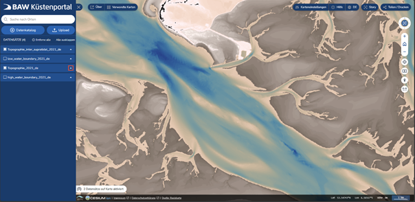
Web feature services for our topographies are now active; hence you can now hit the download button and apply these data in your applications. A citable data DOI is in the making and will be ready soon.
| TrilaWatt Newsletter November 2024 |
|---|
The TrilaWatt project is ending soon and we look forward to presenting the result of three years of work. Recently, all topography data were uploaded to our data platform and are now available. Sediment and hydrographic data will follow until the end of this year or in early 2025. We would be enthusiastic about receiving your feedback about our most recent uploads.
Save the date: TrilaWatt results will be presented on 06th February 2025 in several online talks. We are still working on the agenda – so keep an eye out for more news coming later this year. You are receiving this newsletter because you have shown interest in the TrilaWatt project.
Online result presentation
We invite you to participate in our result presentation on 06th February 2024 from 10 – 12 CET. Three years of intense research and data gathering passed – now we want to take you on a journey from where we started in TrilaWatt to today’s results. Talks will include the topics: Geomorphology, surface sediments, hydrodynamics and sediment transport, web functionality, and discussions. Registration opens soon!
Bathymetry data products
We have unified our web viewer with previously existing infrastructure and coastal data in the new BAW coastal information system (see example below). Coastal data for the Wadden Sea are now gathered in one place and you can profit from a coherent data starting in the year 1996. We have also reorganized the structure and added sublayers for easier navigation.
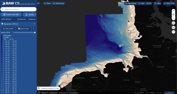
Web feature services for our topographies are now active; hence you can now hit the download button and apply these data in your applications. A citable data DOI is in the making and will be ready soon – a first glance is available our the preliminary meta data.
Use-cases
We are grateful for every stakeholder that invested time and purpose to aid our TrilaWatt research initiative. Thank you. The stakeholder participation process was now published as technical reports with DOI and can be accessed online. Use cases range from tidal energy to intertidal zone classification, or tidal propagation for LiDAR campaigns – make sure to check if this is of interest to your work and get in touch with us. More applications are underway.
| TrilaWatt Newsletter November 2023 |
|---|
The TrilaWatt research project has been busy gathering and consolidating the data you have generously provided for us. We have just started uploading first data products that can already be accessed online through our viewer. Our next steps are data-driven and numerical simulations to derive surface sediment and tidal dynamic data products. You are receiving this newsletter because you have shown interest in the TrilaWatt project.
Project status
Our work in 2023 was, again, focused on gathering and uniting various data from the trilateral administration and from you – our stakeholders. Currently, these data are applied in the data-driven and numerical models which we will feature in further data products of the year 2020. More data products are expected early 2024.
New data is online
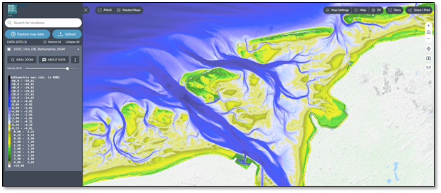
We can now present the first bathymetry data in our interactive web viewer as view-only in the years 2005, 2010, and 2015 to 2022 in the German Bight. Data were computed on regular 10 m grids. All data can also be obtained from the Waddenviewer of the Rijkswaterstaat Datahuis. Bathymetry in the Dutch Wadden Sea and surface sediment information will follow early 2024.
Stakeholder participation results
We are grateful for every stakeholder that invested time and purpose to aid our TrilaWatt research initiative. Thank you. The stakeholder participation was recently completed and we identified and worked on four use-cases:
Sediment management
The estimation of characteristic regional SPM concentrations and of sediment transport pathways is a crucial information in marine spatial planning. TrilaWatt collaborated with the German “Bundesanstalt für Gewässerkunde” to develop suiting data products for this purpose.
Cable route planning
Cable routing for offshore wind-farms requires detailed knowledge about bathymetry and morphodynamics near the coast, as strong erosion may expose this critical infrastructure to the elements. We have developed a web-based WPS functionality with feedback from the North Sea Energy program to estimate the deepest bathymetric value from our data along a user-defined transect to assist with in this critical task.
The parameter intersector
Biological habitats depend on several properties such as inundation, salinity, current velocity, shear stress, or turbity. To aid in identifying habitats, or other areas of interest with specific properties, a parameter intersector was developed as a web-based WPS functionality. This feature generates parameter intersections on-the-fly and enables a download option for the result.
MSRL reports
The TrilaWatt consortium collaborated with a working group of the German administration to assist in German and European reporting duties with data contributions.
| TrilaWatt Newsletter March 2023 |
|---|
We are overwhelmed from the broad participation and your feedback at the 2nd online TrilaWatt stakeholder workshop from February 16th. We wish to present a short summary and conclusion to the workshop and give an outlook to upcoming features and new data products. As always, you may contact usfor questions, collaboration, or data matters. You are receiving this newsletter because you have shown interest in the TrilaWatt project.
Project status
We started the TrilaWatt workshop by giving a brief overview about our research in the past year. Significant progress has been made with bathymetry and surface sediment data acquisition. First preliminary data products can therefore already be accessed, browsed, and modified in our interactive web viewer. These data were applied in the numerical model which is currently still being calibrated. We have also conducted small projects with our stakeholders that we synthesized in use-cases. Note that all data and the viewer itself are still under development. Our presentation slides can be obtained here.
Workshop summary
After reporting the TrilaWatt project progress, we had four interactive breakout sessions. The first session “Geomorphology and surface sediments” discussed analyses on changes in mudflat distribution, surface sediment sample availability, and possibilities to assess data confidence. Furthermore, the need for integrating new surveys into the annual bathymetries was expressed. The second session “Tidal dynamics and sediment transport” reviewed the file format and resolution of the final data products with a mentimeter survey. We noted a particular interest in the suspended sediment transport. Waves, currents, and sea surface height at a high resolution were also of interest. “Interactive web viewer and web processing” was the third active participative session. We found that the export of predefined areas, such as tidal basins or user-defined polygons, and a time series export are primary user requirements. Other points of discussion were the use of own data and individual analyses and on-the-fly scripting. In our fourth session “Use-cases and stakeholder participation”, the monitoring of marine litter, ecological and habitat subjects, pipeline layouts, and the collaboration with a biological twin of the Wadden Sea was discussed.
Outlook
Thank you all for your feedback and ideas to the TrilaWatt effort. We will continue to create data for users in the Wadden Sea and look forward to future shared projects in use-cases or to discussing other data matters with you. It remains imperative to our research effort that we gain access to available bathymetry and surface sediment data you feel comfortable to provide.
| TrilaWatt Newsletter 2 February 2023 |
|---|
We are happy to welcome you to the 2nd online TrilaWatt stakeholder workshop this week on February 16th (10:00 to 12:00 CET). You may find the login information and a detailed workshop agenda below. This mail and the login information may still be forwarded to your friends and colleagues for last-minute participation without prior registration.
Workshop login details
All registered participants have been provided with login information to the Webex meeting via Email. You may use our homepage https://trilawatt.eu/en/ to contact us, if you did not receive any Email or if you have any questions.
Workshop agenda
- Introduction and opening remarks
- TrilaWatt project presentation
- Research objective
- Project status and data product information
- User pitches
- Active participation surveys in four breakout rooms:
- Bathymetry and surface sediment
- Tidal dynamics and sediment transport
- Interactive web viewer and web processing
- Use-Cases and stakeholder participation
- Get involved: “Friends of TrilaWatt”
- Concluding remarks
| TrilaWatt Newsletter 1 February 2023 |
|---|
This is a friendly reminder for you to take part in the TrilaWatt workshop next week on February 16th (10:00 to 12:00 CET). Please register and you will receive a WebEx invitation at the beginning of next week. If you have already registered earlier, you may ignore this E-Mail. The workshop’s program can be found here.
| TrilaWatt Newsletter January 2023 |
|---|
We welcome you to the next TrilaWatt workshop on February 16th (10:00 to 12:00 CET). The workshop will be held online with WebEx.
The TrilaWatt stakeholder workshop
The first year of TrilaWatt was characterized by collecting and processing data which has been generously transferred to us. We now wish to present our efforts to you. The first half of our workshop will focus on briefly presenting the project’s objective and our recent progress. We will show how the data of our partners have improved our products and where we see fit for further cooperation. We will also provide a live demonstration of the future web environment. The second half will involve you. The workshop will feature an active mentimeter participation to allow you to share needs and ideas for TrilaWatt data. The meeting structures as follows (draft):
- Introduction and opening remarks
- Project status and live demonstration
- User experiences
- Short break
- Active participation
- Concluding remarks
You will receive a conference invite if you have registered a few days before the meeting. The registration link can be found above.
| TrilaWatt Newsletter December 2022 |
|---|
We have been working steadily on the joint TrilaWatt research initiative in the past year and wish to present a quick update on our work for our participative stakeholders and the interested scientific community on an upcoming online workshop, first results, and our next steps.
The next TrilaWatt stakeholder workshop
The TrilaWatt objective is the synthesis of scattered data in the Trilateral Wadden Sea area to reliable, high-resolution bathymetry, surface sediment, and tidal dynamic data products for research, consulting, and governmental policy decision in the period of 2000 to 2020. Final data products will be available following the FAIR model (free, accessible, interoperable, and re-usable). We wish to invite you for an opportunity to present our current research status and for you to get involved in future data products. The workshop will be held online with WebEx on:
February 16th 2023 from 10:00 to 12:00
We would be happy to receive (optional) feedback or ideas on data products and the web environment with your registration.
First results: Bathymetry and surface sediment data
We started our work by collecting extensive bathymetry and surface sediment information from our trilateral partners in the first year of our research project. These data were used to test our interactive web environment where we plan to develop novel features such as on-the-fly differences or data cropping.
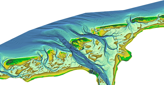
The development of high-resolution bathymetry and surface sediment data (<10m) requires extensive input data and information about tidal dynamics at the study site. To date, we have collected more than 144,000 bathymetry data sets with 370 billion data points and 45,000 surface sediment samples. An exemplary 1 m bathymetry grid of the Dutch-German Ems estuary is shown below. Similar data are planned for the entire Wadden Sea area.
Our next steps
Within the next few months, we aim to collect and organize more data to refine our bathymetric and surface sediment data product collection. The web-viewing environment will be adjusted to handle these high-resolution data and data operations simultaneously. We also develop and calibrate a hydrodynamic numerical model of the North Sea to estimate tidal dynamics, temperature, salinity, and suspended sediment concentration in the study period. The final data products will be just as good as the input data available to us which is why we wish to invite you, the trilateral Wadden Sea stakeholders, to participate in our research effort.
Contact information
We would be happy to stay in contact and to develop and refine data over the course of the next few years in a partnership-like philosophy.
Be sure to visit our homepage https://trilawatt.eu .
Social Contact