
Data products
TrilaWatt creates consistent and harmonized data bases and thus enables area-wide statements for the entire Trilateral Wadden Sea for the first time. This applies to the morphodynamically influenced depth structure as well as to the bottom properties. Based on analyses of hydrodynamic long-term simulations for the entire area, parameters can be determined that characterize the system behavior.
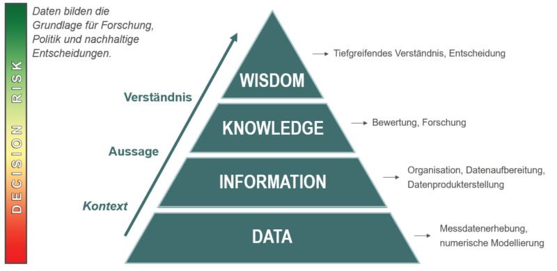
TrilaWatt makes a crucial contribution to the Trilateral Wadden Sea World Heritage Site according to the data-information-knowledge-wisdom (DIKW) concept for collecting, organizing and interpreting data on the way to in-depth system understanding for efficient decision making (Tedeschi 2019).
Based on annually updated data sets on bathymetry, numerical simulation models are used to investigate hydrodynamics, also taking into account variable grain size distributions. The documentation of all results is done with metadata for catalog systems like MDI-DE. Visualization and download of the data products is realized with interactive web services.
TrilaWatt products are based on the products and resolutions of the mFUND project EasyGSH-DB, which was completed in 2020, and continue the time series of EasyGSH-DB data products published and provided there for 1996-2015 from 2015 to 2021 (2022 only as a prototype).
The extensive data products are displayed using Web Mapping Services (WMS) and can usually be downloaded using Web Feature Services (WFS). With the help of Web Processing Services (WPS), sections can be defined interactively, comparisons can be calculated within them, and other user-specific operations can be performed based on the data. They are freely available via geoportals such as mobilithek and GOVDATA.
Geomorphology

Initial situation:
- The relief of the seafloor (e.g. bathymetry) is highly dynamic. Channel displacements of several 100m per year are not uncommon.
- For this reason, regular measurements (soundings) are carried out.
- However, the size of the Wadden Sea (11,000 km²) makes large measurement campaigns impossible, which is why a large number of local soundings are available.
Our contribution:
- We will unify all available data into annual bathymetry data products with 1m grid resolution and make these data available FAIR.
- An example of a 10m bathymetry is given on the left.
Permanent repository: Digital hydro-morphological twin of the Trilateral Wadden Sea TrilaWatt – BAW
Sedimentology

- Surface sediments are less dynamic than bathymetry; nevertheless, their distribution also changes over time
- Surface sediments are sampled far less frequently than bathymetry, which is why data availability has been increased here using data-driven and numerical models.
- As a result, regular 10 m grids have been created in the target area for:
- Average grain diameter (d50) in mm
- Weight percentages of grain fractions in ¼ Ф intervals
- Sorting
- Skewness
- Porosity
- Petrographic maps (main component short) for the German Bight
- Petrographic maps (main component long) for the German Bight
- Petrographic maps (secondary component short) for the German Bight
- Petrographic maps (secondary component long) for the German Bight
Permanent repository: Digital hydro-morphological twin of the Trilateral Wadden Sea TrilaWatt – BAW
The products published here are based on the products and resolutions of the completed mFund project EasyGSH-DB (see: BAW data repository) and continue the time series of products published there until 2021.
Hydrodynamics

- We calculate the entire North Sea for reliable statements in the focus area Trilateral Wadden Sea.
- Result parameters are tide, salinity, temperature and suspended sediment concentration.
- From the simulation data, we determine parameters such as bottom shear stresses, inundation durations, etc., which are suitable for reporting tasks, and
- perform harmonic analyses of the water level.
- The aim is to provide system parameters that are relevant to practice over a wide area and limited in time.
Permanent repository: Digital hydro-morphological twin of the Trilateral Wadden Sea TrilaWatt – BAW
TrilaWatt’s comprehensive data products are displayed using Web Mapping Services (WMS) and are usually downloadable using Web Feature Services (WFS). Wep Processing Services (WPS) can be used to interactively define sections, calculate comparisons within them, and perform other user-specific operations on the data.
Social Contact